Data Processor
Jsc Yuzhmorgeologia
Please complete the CAPTCHA to continue
A concise factual answer block for searchers comparing this professional profile.
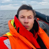
Danil Markuvenas is listed as Data Processor at JSC Yuzhmorgeologia, based in Russia, Russian Federation. AeroLeads shows a matched LinkedIn profile for Danil Markuvenas.
Danil Markuvenas previously worked as Hydrographic Surveyor and navigator at Marine Geodesy and Online surveyor at Denar Ocean Engineering Services Sa. Danil Markuvenas holds Master Of Science - Ms from Государственный Университет Морского И Речного Флота Имени Адмирала С.О. Макарова.
This section adds company-level context without repeating Danil Markuvenas's masked contact details.
Review company-level records connected to Danil Markuvenas before choosing the right outreach path.
With a Master's Degree in offshore engineering, I worked on research vessels as a engineer-hydrographer, seismic-navigator, geophysical engineer and survey engineer. My analytical skills and engineering knowledge let me become a specialist and prove my strong abilities to work in offshore environment. I have also become a strong member of a multicultural team carrying out few live projects having robust communication skills and willingness to develop further in offshore area.The equipment and software with I've worked:Nav: Aplanix PosMV5, Trimble SPS..MBES: R2SONIC;Geodetic: Trimble M3.SBP: Innomar SES 2000,.SSS: Edgetech 4200, Klein 3900.Magnetometer: Geometrics G-882.Seismic survey: Geospace seabed stations, “CRAB” seabed stations.Software: Qinsy, Qimera, HydroPro, Global Mapper, AutoCAD, Discover, SonarWiz,7 Hypack.
Company context helps verify the profile and gives searchers a useful next step.

A career timeline built from the work history available for this profile.
Russia

Стамбул, Турция
Project: PRELAY AND ANCHOR CORRIDOR SURVEY.Client/Survey company: SAIPEM/ DENAR;Area: Black Sea, Turkey; Vessel: M/V Denar Surveyor;Position: Online Surveyor;Duties: Installation and configuration of geophysical and navigation equipment. CASSIUS USBL Sonardyne calibration . Data collection. QC control;Software: Hypack, SonarWiz7, Global Mapper;Equipment: USBL Sonardyne ranger 2, Applanix PosMV5, R2Sonic MBES, SSS EDGE TECH 4200,
Thailand, Pattaya
Client/Survey company: XLinks/ GeoXYZ.Area: Office (Onshore).Project: MOROCCO-UK CABLE ROUTE SURVEYPosition: MBES data processor.Software: Qinsy 9, Qimera.
Project: Nord Stream 2. Inspection Survey 2023 (Russian Nearshore).Position: Engineer-hydrographer, data processor of SSS & MBES.Vessel: SPS IGOR ILYIN.
Project: Construction of a transarctic submarine fiber-optic communication line from Murmansk to Vladivostok.Client: FEDERAL AGENCY FOR MARITIME AND RIVER TRANSPORT, FSUE “Morsviazsputnik”.Duties: Installation and configuration of geophysical and navigation equipment. Offsets measurement. Data collection. QC control. Reporting.Software: QINSY Equipment: Aplanix PosMV5, R2Sonic ins, SES2000 SBP
Project: 3D Seismic survey. Equipment: USBL Sonardyne, Trimble SPS, AIS, Integra, 4GNSS.Soft: HydroPro, Global Mapper.Vessel: VYBORGSKIY.Location: Bay of Ob.Customer: NOVATEK

Москва, Россия
Type of work: 3D/4С seismic.Technology: “CRAB” seabed stations.Multi Purpose offshore vessel "Steady Kestrel".Location: Sakhalin Island continental shelf, Okhotsk Sea.Customer: Gazprom Neft Shelf.
Санкт-Петербург, Санкт-Петербург, Россия
Type of work: Subsea survey for cable laying.Vessel: R/V Hydrograph Zhdanov.Technology: Side scan sonar, Mag Geometrics G882, MBES, SBP survey.Soft: HypackLocation: Avacha Bay, Customer: Huawei Technologies Co., Ltd.
Таллин, Эстония
Type of work: 3D seismic survey; Position: Geophysicist, QC Engineer.Technology: Q-Marine; Number of streams: 10; Stream length: 10 km.Duties: Quality control and processing of marine seismic data in Open CPS and RadExPro software. Seismic processing workflows execution, navigation data input, swell noise attenuation, spikes, line noise attenuation; building velocity models, installation and recovery of geophysical equipment, streamer deck work as required.R/V: Ivan Gubkin (SW BLY); Location: Offshore Senegal, Atlantic Ocean.

Geophysicist online. Survey engineer.Type of project: Subsea Infrastructure Survey of Chayvo, De-Kastri, Tatar Strait and Arkutun-Dagi.Soft: SonarWiz, Discover, GeoSute.Used equipment:Side Scan Sonar EDGE TECH 4125; Magnetometer Geometrics G-882;EdgeTech Sub-Bottom Profiling System, GeoPuls SBP systems.Vessel: R/V Ivan Kireev.The customer Exxon Neftegas Limited, Offshore Sakhalin.
Wellhead inspection for wells drilled in the past years within the subsoil area of the Federal importance including the North-Veni gas condensate field.Operator of Side Scan Sonar EDGE TECH 4125, Magnetometer Geometrics G-882, EdgeTech Sub-Bottom Profiling System, GeoPuls SBP systems.Soft: SonarWiz, Discover, GeoSute.Vessel: R/V Ivan Kireev.The customer: Venineft LLC, Offshore Sakhalin, Russia.
Geophysicist online. Survey engineer.Type of project: Subsea Infrastructure Survey of Chayvo, De-Kastri, Tatar Strait and Arkutun-Dagi.Soft: SonarWiz, Discover, GeoSute.Used equipment:Side Scan Sonar EDGE TECH 4125; Magnetometer Geometrics G-882;EdgeTech Sub-Bottom Profiling System, GeoPuls SBP systems.Vessel: R/V Ivan Kireev.The customer Exxon Neftegas Limited, Offshore Sakhalin.
Южно-Сахалинск, Сахалинская Область, Россия
Type of work: UXO Survey. Geophysical surveys for detecting, identifications and the organizations of destruction of explosive subjects on water area and a coastal zone in the Aniva Bay on a place of planned mooring LNG.Technology: Side Scan Sonar EDGE TECH 4125;Magnetometer Geometrics G-882;EdgeTech Sub-Bottom Profiling System, GeoPuls SBP systems.Soft: SonarWiz, Discover, GeoSute.Vessel: R/V Ivan Kireev.The customer: Sakhalin Energy. Location: Offshore Sakhalin, Okhotsk Sea, Russia.
Seismic data processor.Software: instrumental processing complex «GeoCluster-3100, 4100, 5000» (CGG Veritas).
Survey Engineer. Online, operator of Acoustic complex МАК-1М (SSS+SBP). Also used: Box corer.Customer: «Nautilus Minerals».Project and area of works: deposit polymetallic nodules in Pacific ocean (Clarion-Clipperton zone).Vessel: R/V "Yuzhmorgeologia".
2D seismic survey in Khatanga Bay. Duties: Mobilization of vessel. Seismic streamers control, setup, operating and maintaining seismic system (Aram Aries II).
3D seismic survey in Barents Sea. Duties: Mobilization of vessel. Seismic streamers control, setup, operating and maintaining seismic system (Aram Aries II).Vessel: MV "ANTEY".Customer: PJSC Rosneft.


Quick answers generated from the profile data available on this page.
Danil Markuvenas works for JSC Yuzhmorgeologia.
Danil Markuvenas is listed as Data Processor at JSC Yuzhmorgeologia.
Danil Markuvenas is based in Russia, Russian Federation while working with JSC Yuzhmorgeologia.
Danil Markuvenas has worked for Jsc Yuzhmorgeologia, Marine Geodesy, Denar Ocean Engineering Services Sa, Geoxyz, and Fertoing Ltd..
You can use AeroLeads to view verified contact signals for Danil Markuvenas at JSC Yuzhmorgeologia, including work email, phone, and LinkedIn data when available.
Danil Markuvenas holds Master Of Science - Ms from Государственный Университет Морского И Речного Флота Имени Адмирала С.О. Макарова.
Search by job title, company, industry, location, and seniority. Export verified B2B contact data when you need it.
Start free trial Search contacts