Ernesto “Ernie” Montes De Oca work email
- Valid
- Valid
- Valid
Ernesto “Ernie” Montes De Oca personal email
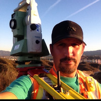
I do what I love and I love what I do!I've had the pleasure of being in the surveying industry for the past 15+ years and I have to say, it has been a blast.Since the very first day I went out on a survey crew I absolutely loved it. I got to do a boundary and topography survey in the Santa Monica mountains. From the ride to the project site, setting up the instrument, hacking through some brush with a machete to get to the rear corners, setting two, 2 inch iron pipes with tags, data collecting the house location and other features, etc, etc... I was absolutely hooked! The next day I had the pleasure of drafting the map and drafting the corner record for submittal to the county of Los Angeles. It was such a great balance of fieldwork and office work and after that day I realized what I wanted to do for the rest of my life. I am very fortunate to have landed where I was at and have enjoyed this journey to where I am at now.
-
 OwnerMdo And Company Jan 2013 - Present
 -
 Senior Land TechnicianPacific Gas And Electric Company Jan 2020 - PresentOakland, California, UsTeam member of the Bakersfield Land Distribution Team providing surveying services to all of Kern County. • Project management of survey projects.• Coordination with local and state agencies (Cal-Trans, public works, planning departments, county roads department, etc.), and inter-office design teams.• Calculate boundary, control set-up, construction calculations for field surveys, and coordinate with survey crews.• Prepare Legal Descriptions and Plats for easement documents; prepare survey exhibits, as-builts, etc.for Cal Trans and railroad permits• Prepare plans and maps from field survey work. Coordination of plans/maps with project teams.• Research of property ownership, boundary record maps, utility, highway, benchmark maps, etc…
 -
Employee Engagement Team MemberPacific Gas And Electric Company Mar 2018 - PresentOakland, California, Us• Help promote a proper work/life balance.• Coordination with team to promote and execute employee functions with their teams and family members.• Peer-2-Peer monthly drawing team lead.
-
Land TechnicianPacific Gas And Electric Company Jan 2019 - Jan 2020Oakland, California, UsTeam member of the Fresno Land Distribution Team• Project management of survey projects.• Coordination with local and state agencies (Cal-Trans, public works, planning departments, county roads department, etc.), and inter-office design teams.• Calculate boundary, control set-up, construction calculations for field surveys, and coordinate with survey crews.• Prepare Legal Descriptions and Plats for easement documents; prepare survey exhibits, as-builts, etc.for Cal Trans permits• Prepare plans and maps from field survey work. Coordination of plans/maps with project teams.• Research of property ownership, boundary record maps, utility, highway, benchmark maps, etc…
-
Land Technician - PsepPacific Gas And Electric Company Jun 2018 - Jan 2019Oakland, California, UsTeam member of the Land Department Transmission team that is based out of the San Ramon Bishop Ranch office.• Project management of survey projects.• Coordination with local and state agencies (DOGGR, Cal-Trans, public works, planning departments, etc.), and inter-office design teams.• Calculate boundary, control set-up, construction calculations for field surveys, and coordinate with survey crews.• Prepare Legal Descriptions and Plats; prepare survey exhibits, as-builts, etc.• Prepare plans and maps from field survey work. Coordination of plans/maps with project teams.• Research of boundary record maps, utility, highway, benchmark maps, etc…
-
Land Technician - CpsiPacific Gas And Electric Company Oct 2017 - Jun 2018Oakland, California, UsTeam member of the Land Department team that specializes in System Wide Survey Support (SWiSS) for the Community Pipeline Safety Initiative (CPSI).• Project management of survey projects.• Coordination with local and state agencies (Cal-Trans, public works, planning departments, etc.), and inter-office design teams.• Calculate boundary, control set-up, construction calculations for field surveys, and coordinate with survey crews.• Prepare Legal Descriptions and Plats; prepare survey exhibits, as-builts, etc.• Prepare plans and maps from field survey work. Coordination of plans/maps with project teams.• Research of boundary record maps, utility, highway, benchmark maps, etc…
-
 Senior Survey Technician / Party ChiefDewalt Corporation Jul 2016 - Oct 2017Bakersfield, Ca, UsGeneral:• Cost estimates for projects.• Project and personnel management.• CAD Standards Management for Survey Department• Research information (project specific as needed)• Autodesk AutoCAD 2013-2015• Autodesk Civil 3D 2013-2015• Autodesk Map 2015• Autodesk Navisworks 2013-2015• Autodesk Raster Design 2015• Autodesk ReCap• RealityLINx 3D modeling software suites• Google EarthSurvey:• Architectural, ALTA/NSPS Land Title Surveys, Topography, Aerial, Boundary, Construction Staking, As-Built Surveys, Legal Descriptions and Plats, Tract and Parcel Maps.• Research of boundary, utility, highway, benchmark maps, etc…• As-built surveys, Plan and Profile of pipeline alignments (existing and proposed). • Calculate boundary and control set-up for field surveys, coordinate with survey crews.• Draftsman for Special Projects.• Field work as needed/required.• Provide surveying support for field operations, construction and mechanical engineering department.• Survey supply requisition.• Surveying Instruments:••• Trimble S8 Robotic Total Station••• Trimble TSC3 Data CollectorLaser Scanning:• Performance and management of laser scans and survey data.• Performance of Laser Scanning equipment and related software products.• Field work as needed/required.• Laser Scanning Instruments:Utility Line Locating:• Locate underground utility lines for future development.• Draft exhibit of findings.
 -
 Surveying And Laser Scan Division SupervisorIes Engineering Aug 2014 - Jul 2016Bakersfield, Ca, UsGeneral:• Cost estimates for projects.• Project and personnel management.• CAD Standards Management for Survey Department• Research information (project specific as needed)• Autodesk AutoCAD 2013-2015• Autodesk Civil 3D 2013-2015• Autodesk Map 2015• Autodesk Navisworks 2013-2015• Autodesk Raster Design 2015• Autodesk ReCap• PDMS Modules including LFM, LMI, Design, and Drafting• RealityLINx 3D modeling software suites• Z+F Laser Control Professional• Google EarthSurvey:• As-built surveys, Plan and Profile of pipeline alignments (existing and proposed). • Calculate boundary and control set-up for field surveys, coordinate with survey crews.• Draftsman for Special Projects.• Field work as needed/required.• Provide surveying support for field operations, construction and mechanical engineering department.• Survey supply requisition.• Surveying Instruments:••• Trimble S8 Robotic Total Station••• Trimble TSC3 Data Collector••• Leica TS15i Robotic Total Station••• Leica CS15 Data Collector••• Spectra Precision SP80 GPSLaser Scanning:• Performance and management of laser scans and survey data.• Performance of Laser Scanning equipment and related software products.• Field work as needed/required.• Laser Scanning Instruments:••• Z+F 5010C 3D Laser ScannerUtility Line Locating:• Locate underground utility lines for future development.• Draft exhibit of findings.• Line Locating Instruments:••• Ridgid SeekTech SR-60
 -
Laser Scan Division SupervisorIes Engineering Feb 2014 - Aug 2014Bakersfield, Ca, UsResponsible for the day to day operations of the Laser Scan Division at IES Engineers.General:• Cost estimates for projects.• Project and personnel management.• Autodesk AutoCAD 2013-2014• Autodesk Civil 3D 2013-2014• Autodesk Map 2014• Autodesk Navisworks 2013-2014• Autodesk Raster Design 2014• PDMS Modules including LFM, LMI, Design, and Drafting• RealityLINx software suites• Z+F Laser Control ProfessionalLaser Scanning:• Performance and management of laser scans and survey data.• Performance of Laser Scanning equipment and related software products.• Field work as needed/required.
-
Land Survey / 3D Laser Scan SpecialistIes Engineering Dec 2013 - Feb 2014Bakersfield, Ca, UsGeneral:• Autodesk AutoCAD 2013-2014• Autodesk Civil 3D 2013-2014• Autodesk Map 2014• Autodesk Navisworks 2013-2014• Autodesk Raster Design 2014• PDMS Modules including LFM, LMI, Design, and Drafting.Laser Scanning:• Performance and management of laser scans and survey data.• Performance of Laser Scanning equipment and related software products.• Field work as needed/required.
-
Survey SpecialistTechnical Services & Management, Inc. Feb 2013 - Dec 2013General:• Autodesk AutoCAD 2013-2014• Autodesk Civil 3D 2013-2014• Autodesk Map 2014• Autodesk Navisworks 2013-2014• Autodesk Raster Design 2014• PDMS Modules including LFM, LMI, Design, and Drafting.Laser Scanning:• Performance and management of laser scans and survey data.• Performance of Laser Scanning equipment and related software products.• Field work as needed/required.
-
 Cad Manager / Survey TechnicianDiversified Project Services International, Inc. Jul 2010 - Feb 2013Bakersfield, Ca, UsGeneral:• CAD Standards Management• Autodesk AutoCAD 2010-2013; Carlson Civil Suite 2010-2013• Research information (project specific as needed)• Office handy-man.Survey:• As-built surveys, Plan and Profile of pipeline alignments (existing and proposed). • Tract Maps, Record of Survey Maps, ALTA/ASCM, Exhibits, Legal Descriptions & Plats, COGO.• Calculate boundary and control set-up for field surveys, coordinate with survey crews.• Draftsman for Special Projects.• Field work as needed.• Provide surveying support for field operations, construction and mechanical engineering department.• Survey supply requisition.
 -
Project Manager / Cogo Database ManagerSikand Engineering Assoc. Dec 2003 - Sep 2009General:• Project Management• Autodesk Land Development Desktop R3 - 2009; AutoCAD CivilSurvey:• Tract Maps, Record of Survey Maps, ALTA/ASCM, Exhibits, Legal Descriptions & Plats, COGO.• Calculate boundary and control set-up for field surveys, coordinate with survey crews.• COGO File Manager.• Draftsman for Special Projects.
-
Project Manager / Senior DraftsmanCarl Betz And Associates, Inc. Nov 1998 - Dec 2003• Autodesk Land Development Desktop R1 - R3• Architectural, ALTA/ASCM, Topography, Aerial, Boundary, Construction Staking, As-Built Surveys. • Research of boundary, utility, highway, benchmark maps, etc…• Supervisor of field survey operations with 2 - 3 man crews.
-
Draftsman / ChainmanGeosystems 1998 - 1999• Autodesk Land Development Desktop R1/ACAD R14• Draftsman / Chain man for survey department.• Research of boundary, utility, highway, benchmark maps, etc…• Draftsman for Geologist department.
Ernesto “Ernie” Montes De Oca Skills
Ernesto “Ernie” Montes De Oca Education Details
-
 Bakersfield CollegeAutocad
 -
Itt Technical InstituteComputer Aided-Drafting & Design (Cadd)
Frequently Asked Questions about Ernesto “Ernie” Montes De Oca
What company does Ernesto “Ernie” Montes De Oca work for?
Ernesto “Ernie” Montes De Oca works for Mdo And Company
What is Ernesto “Ernie” Montes De Oca's role at the current company?
Ernesto “Ernie” Montes De Oca's current role is Owner at MDO & Company.
What is Ernesto “Ernie” Montes De Oca's email address?
Ernesto “Ernie” Montes De Oca's email address is er****@****bal.net
What schools did Ernesto “Ernie” Montes De Oca attend?
Ernesto “Ernie” Montes De Oca attended Bakersfield College, Itt Technical Institute.
What are some of Ernesto “Ernie” Montes De Oca's interests?
Ernesto “Ernie” Montes De Oca has interest in Family, Laser Scanning, Children, Project Management, Education, Educación, Arts And Culture, Scouting And Skateboarding, Infancia, Surveying.
What skills is Ernesto “Ernie” Montes De Oca known for?
Ernesto “Ernie” Montes De Oca has skills like Surveying, Topographic Surveys, Autocad, Boundary, Cad, Land Development, Laser Scanning, Construction, Legal Descriptions, Gps, Subdivisions, Pipelines.
Free Chrome Extension
Find emails, phones & company data instantly
Aero Online
Your AI prospecting assistant
Select data to include:
0 records × $0.02 per record
Download 750 million emails and 100 million phone numbers
Access emails and phone numbers of over 750 million business users. Instantly download verified profiles using 20+ filters, including location, job title, company, function, and industry.
Start your free trial