Martin Chege Email and Phone Number
As a Research Assistant at the Remote Sensing Research Group (RSRG) of DeKUT and a GIS Developer at Anmart Developers Ltd, I apply my skills and knowledge in geospatial science, web development, and remote sensing to create innovative solutions for the water and agriculture domains. Some of my achievements include developing content for e-learning, creating technologies for monitoring water quality, facilitating stakeholder involvement, coordinating and implementing custom solutions for smart agriculture, and doing spatial data analytics. I also supported the launch of a satellite tracking project with the Italian Space Agency, and published a report on the Kenya space agency policy.I hold a Bachelor's degree in Geomatics and geospatial information science and remote sensing from DeKUT, and I am currently pursuing a Master of Science in the same field from the same university. I have also obtained multiple certifications in photogrammetry, remote sensing, and ArcGIS. I am passionate about using open source tools and technologies to advance research and development in geospatial science and remote sensing.

-
CartographerDedan Kimathi University Of Technology (Dekut)Nyeri, Nyeri County, Ke
-
 Project ManagerAnmart Developers Ltd Feb 2023 - PresentNyeri, Kenya-Leading a team of software developers to work on solutions that deliver satellite based smart agriculture solutions.-Project monitoring of the quality of software we are delivering to clients.- Mentoring young and upcoming GIS software developers within the projects
 -
Geographic Information Systems EngineerAnmart Developers & Surveyors Feb 2022 - PresentDoing Spatial Data analytics, as wel as developing tailor made spatial solutions.
-
Lead SurveyorAnmart Developers & Surveyors Jan 2022 - Aug 2023Kenya
-
Research AssistantDedan Kimathi University Of Technology (Dekut) Aug 2023 - PresentNyeri, KenyaMy current position is that of a research assistant at the Remote Sensing Research Group (RSRG), where I help carry out studies pertaining to the water domain. - In addition, I have assisted with and worked on additional deliverables, such as the development of content for elearning.- The creation of technologies for monitoring water quality that are inexpensive.- Facilitating consultative stakeholder involvement in order to organize community participation in research that is both ongoing and ongoing.
-
Research InternDedan Kimathi University Of Technology (Dekut) May 2022 - Jul 2023Nyeri, KenyaParticipated in a variety of tasks within the Remote Sensing Research Group (RSRG) team, including supporting data analysis, the establishment and maintenance of spatial databases within the project server, and the design and development of research variables.
-
 Land Surveyor & Gis DeveloperServdev Geosolutions 2017 - Dec 2021
 -
Frontend Web DeveloperServdev Geosolutions Aug 2019 - Dec 2020KenyaI am currently working as a remote web developer and also a wordpress developer with the aim of revolutionalizing the web apps and taking them to a new level also gone ahead to carry out my remote sensing analysis on the web apps demonstrating that everything and anything can be done on the web currently working as a freelancer
-
 Land SurveyorGeodev Kenya Limited Mar 2021 - Aug 2021Nairobi, KenyaDaily activities* To employ geographic information system (GIS) to analyze and understand site features* To assemble comprehensive data (subsequently analysed by planners, builders and cartographers)* To conduct surveys, a variety of tools are used, including GPS and traditional approaches.Before handing out material to other specialists, properly examine it.* Take measurements of the ground, including tiny and large-scale distances, angles, and elevations.* Trough surveys, collect data about the earth's physical and man-made aspects* Data processing* To carry out digital mapping* To tackle practical planning and development difficulties, think beyond the box.* Cartograpghic design ofMaps, charts, and plans Using GIS and CAD based softwares.* To utilise Data from a variety of sources, such as aerial photography, satellite surveys, and laser beam measuring systems.* To interpret data and show information, employ computer-aided design (CAD) and other IT technologies.
 -
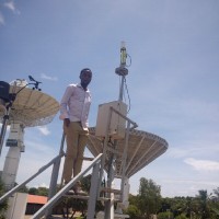
Satelite Tracking || Remote Sensing Analyst || Ariane Space Launch SupportItalian Space Agency Jan 2020 - Mar 2020KenyaBeing a remote sensing analyst at Italian space agency (san marco project) has been such a nice experience being exposed to the exposed to space technology ,satellite telecomands, launch support (Ariane) to real time data aquisition and transimission to the clients has had a big impact on my carrer.
Martin Chege Education Details
-
Geomatics And Geospatial Information Science And Remote Sensing
-
Master Of Science In Geospatial Information Systems And Remote Sensing
Frequently Asked Questions about Martin Chege
What company does Martin Chege work for?
Martin Chege works for Dedan Kimathi University Of Technology (Dekut)
What is Martin Chege's role at the current company?
Martin Chege's current role is Cartographer.
What schools did Martin Chege attend?
Martin Chege attended Dedan Kimathi University Of Technology (Dekut), Dedan Kimathi University Of Technology (Dekut).
Not the Martin Chege you were looking for?
-

Martin Chege
Full Stack Web Developer | Hacking Enthusiast | Farmer| Founder: Peakline TechnologiesNairobi County, Kenya -
 1minet.co.ke
 -


Free Chrome Extension
Find emails, phones & company data instantly
Aero Online
Your AI prospecting assistant
Select data to include:
0 records × $0.02 per record
Download 750 million emails and 100 million phone numbers
Access emails and phone numbers of over 750 million business users. Instantly download verified profiles using 20+ filters, including location, job title, company, function, and industry.
Start your free trial