
AeroLeads people directory · profile
Gary Mccall Email & Phone Number
Aerial Photo Mapping and Lidar Engineer. Norwegian operations
at
Hexagon Geosystems
1 work email found
@blomasa.com
LinkedIn matched
✓ Verified Jun 2026
4 data sources
Profile completeness 100%
Current company
Role
Aerial Photo Mapping and Lidar Engineer. Norwegian operations
Location
Nannestad, Viken, Norway
Company size
Who is Gary Mccall? Overview
A concise factual answer block for searchers comparing this professional profile.
Quick answer
Gary Mccall is listed as Aerial Photo Mapping and Lidar Engineer. Norwegian operations at Hexagon Geosystems, a company with 742 employees, based in Nannestad, Viken, Norway. AeroLeads shows a work email signal at blomasa.com and a matched LinkedIn profile for Gary Mccall.
Gary Mccall previously worked as Aerial Photo Mapping & Lidar Engineer. Norwegian operations at Hexagon Geosystems and Surf & Aerial Photographer at Gmc Photography. Gary Mccall holds Higher National Diploma, Photography from South Eastern Regional College.
Company email context
Email format at Hexagon Geosystems
This section adds company-level context without repeating Gary Mccall's masked contact details.
{first}.{last}@blomasa.com
86% confidence
AeroLeads found 1 current-domain work email signal for Gary Mccall. Compare company email patterns before reaching out.
Profile bio
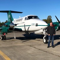
About Gary Mccall
Aerial mapping sensor specialist. In the last 18 years I have flown over 6000 hours capturing aerial photo and LiDAR on major projects throughout Europe, Middle East and Africa. Each winter season I also specialise as a freelance commercial photographer focused on surf and ocean based imagery for commercial use. 🌊 www.gary-mccall.com
Listed skills include Aerial Photography, Lidar, Gps, Surveying, and 20 others.
Current workplace
Gary Mccall's current company
Company context helps verify the profile and gives searchers a useful next step.
Hexagon Geosystems
12 roles · 16 years
Gary Mccall work experience
A career timeline built from the work history available for this profile.
Aerial Photo Mapping & Lidar Engineer. Norwegian Operations
Current
Sep 2021 - Present
Surf & Aerial Photographer
Current
Gmc Photography
- Specialising in heavy surf, water, adventure photography based in Ireland
- Aerial mapping photographer covering all of Scandinavia with special operations in Norway.
2010 - Present
~16 yrs 5 mos

Aerial Mapping - Photo & Lidar System Engineer
Jun 2018 - Aug 2021

Airborne Photo Sensor Operator
Planning and operation of high altitude mapping flights using Ultracam Eagle installed in Piper Cheyenne & Cessna 402OSGB Mapping
Aug 2017 - Nov 2017
Airborne Survey Engineer
Blom Aerofilms
Norwegian Photo License & National IDOperating..Riegl 1560Ultracam EAGLE & XPMIDAS ObliqueLEICA ALS50 & ADS100
Jan 2015 - Jan 2017

Aerial Data Acquisition
Management, maintenance, installations, operation and training on large and medium format camera systems with integrated GNSS + INS systems. Leica, Vexcel Ultracam, Phase One & Zeiss cameras.Flight planning & airspace coordination for projects throughout Europe and post processing of imagery and GPS/IMU data.Riegl & Flimap LiDAR system operations.
Jan 2014 - Dec 2014
Volunteer Photographer - Nepal Rural Aid Project
Volunteer Aid Nepal
Working as a volunteer, photographing and profiling 50 rural homestays and the lifestyles in 10 villages around Pokhara in the Kaski district of Nepal as part of a rural tourism project.http://garymccall.smugmug.com/Nepal-Rural-village-photograph
Nov 2013 - Dec 2013
Freelance Airborne Survey Engineer - Fugro Geospatial
Responsibilities-Installation, mobilisation and maintenance of large format gyro stabilised aerial camera systems-Inflight operation of large format digital cameras for high and low level photogrammetric surveys in various twin engine piston and turbine aircraft. -Inflight operation of LIDAR sensors in helicopter and various twin engine piston.
Mar 2012 - Oct 2013
Aerial Mapping Photographer
Bks Surveys (Fugro-Bks)
Aerial camera operations on projects throughout Europe and Africa using large format RC30 film and Zeiss DMC digital cameras.Creating flight plans and obtaining appropriate airspace clearances. Large format laboratory C41 processing and RA4 printing.Large format scanning and archiving of data sets.Georeferencing areas for flight planning in geodetic datums
Feb 2005 - Mar 2010
Image Archivist & Photoshop Tutor
Belfast Exposed
Digitising a large collection of historical images taken during the troubles in Northern Ireland.Guiding new students through basic photoshop tutorials
Jun 2001 - Mar 2002
Photographic Printer
Fotofast Belfast
RA4 colour printing on Fuji Minilab. C41 and E6 film processing of 35mm and medium format.Photo restoration
Jan 2000 - Oct 2001
Team & coworkers
Colleagues at Hexagon Geosystems
Other employees you can reach at hexagongeosystems.com. View company contacts for 742 employees →
YN
 Yashpal Negi
Colleague at Hexagon GeosystemsSouth Delhi, Delhi, India, India
View →
DP
Yashpal Negi
Colleague at Hexagon GeosystemsSouth Delhi, Delhi, India, India
View →
DP
 Divya Ponnala
Colleague at Hexagon GeosystemsTelangana, India, India
View →
BK
Divya Ponnala
Colleague at Hexagon GeosystemsTelangana, India, India
View →
BK
 Bharath Kumar K
Colleague at Hexagon GeosystemsBengaluru, Karnataka, India, India
View →
SM
Bharath Kumar K
Colleague at Hexagon GeosystemsBengaluru, Karnataka, India, India
View →
SM
 Saravanan Ms
Colleague at Hexagon GeosystemsMadurai, Tamil Nadu, India, India
View →
NS
Saravanan Ms
Colleague at Hexagon GeosystemsMadurai, Tamil Nadu, India, India
View →
NS
 Nagarjun Sharma
Colleague at Hexagon GeosystemsGurgaon, Haryana, India, India
View →
KM
Nagarjun Sharma
Colleague at Hexagon GeosystemsGurgaon, Haryana, India, India
View →
KM
 Krishna Moorthi
Colleague at Hexagon GeosystemsTamil Nadu, India, India
View →
JF
Krishna Moorthi
Colleague at Hexagon GeosystemsTamil Nadu, India, India
View →
JF
 John Fraser Meng Fcinstces
Colleague at Hexagon GeosystemsLoughborough, England, United Kingdom, United Kingdom
View →
AR
John Fraser Meng Fcinstces
Colleague at Hexagon GeosystemsLoughborough, England, United Kingdom, United Kingdom
View →
AR
 Ali Raza
Colleague at Hexagon GeosystemsGujranwala, Punjab, Pakistan, Pakistan
View →
ME
Ali Raza
Colleague at Hexagon GeosystemsGujranwala, Punjab, Pakistan, Pakistan
View →
ME
 Mark Elliott
Colleague at Hexagon GeosystemsPerth, Western Australia, Australia, Australia
View →
AM
Mark Elliott
Colleague at Hexagon GeosystemsPerth, Western Australia, Australia, Australia
View →
AM
 Augusto Merlo
Colleague at Hexagon GeosystemsMantua, Lombardy, Italy, Italy
View →
Augusto Merlo
Colleague at Hexagon GeosystemsMantua, Lombardy, Italy, Italy
View →
Yashpal Negi
Colleague at Hexagon GeosystemsSouth Delhi, Delhi, India, India
View →
DP
Divya Ponnala
Colleague at Hexagon GeosystemsTelangana, India, India
View →
BK
Bharath Kumar K
Colleague at Hexagon GeosystemsBengaluru, Karnataka, India, India
View →
SM
Saravanan Ms
Colleague at Hexagon GeosystemsMadurai, Tamil Nadu, India, India
View →
NS
Nagarjun Sharma
Colleague at Hexagon GeosystemsGurgaon, Haryana, India, India
View →
KM
Krishna Moorthi
Colleague at Hexagon GeosystemsTamil Nadu, India, India
View →
JF
John Fraser Meng Fcinstces
Colleague at Hexagon GeosystemsLoughborough, England, United Kingdom, United Kingdom
View →
AR
Ali Raza
Colleague at Hexagon GeosystemsGujranwala, Punjab, Pakistan, Pakistan
View →
ME
Mark Elliott
Colleague at Hexagon GeosystemsPerth, Western Australia, Australia, Australia
View →
AM
Augusto Merlo
Colleague at Hexagon GeosystemsMantua, Lombardy, Italy, Italy
View →
1 education record
Gary Mccall education
-
 South Eastern Regional College
FAQ
Frequently asked questions about Gary Mccall
Quick answers generated from the profile data available on this page.
What company does Gary Mccall work for?
Gary Mccall works for Hexagon Geosystems.
What is Gary Mccall's role at Hexagon Geosystems?
Gary Mccall is listed as Aerial Photo Mapping and Lidar Engineer. Norwegian operations at Hexagon Geosystems.
What is Gary Mccall's email address?
AeroLeads has found 1 work email signal at @blomasa.com for Gary Mccall at Hexagon Geosystems.
Where is Gary Mccall based?
Gary Mccall is based in Nannestad, Viken, Norway while working with Hexagon Geosystems.
What companies has Gary Mccall worked for?
Gary Mccall has worked for Hexagon Geosystems, Gmc Photography, Cowi, Getmapping, and Blom Aerofilms.
Who are Gary Mccall's colleagues at Hexagon Geosystems?
Gary Mccall's colleagues at Hexagon Geosystems include Yashpal Negi, Divya Ponnala, Bharath Kumar K, Saravanan Ms, and Nagarjun Sharma.
How can I contact Gary Mccall?
You can use AeroLeads to view verified contact signals for Gary Mccall at Hexagon Geosystems, including work email, phone, and LinkedIn data when available.
What schools did Gary Mccall attend?
Gary Mccall holds Higher National Diploma, Photography from South Eastern Regional College.
What skills is Gary Mccall known for?
Gary Mccall is listed with skills including Aerial Photography, Lidar, Gps, Surveying, Remote Sensing, Travel Photography, Photography, and Aerial Surveys.
Find 750M verified contacts
Search by job title, company, industry, location, and seniority. Export verified B2B contact data when you need it.
Start free trialPeople with similar names
Check these profiles if this is not the Gary Mccall you were looking for.

Gary McCall
2 email domains

Gary McCall
2 email domains


Gary McCall
4 email domains

Gary McCall
7 email domains